

JPL tests an Arctic sea-ice sensor, flying 50 hours to prep for a launch in a year
A two-week Canadian campaign timed aircraft and satellites to improve sea-ice thickness measurements that matter for climate, navigation, and future missions.
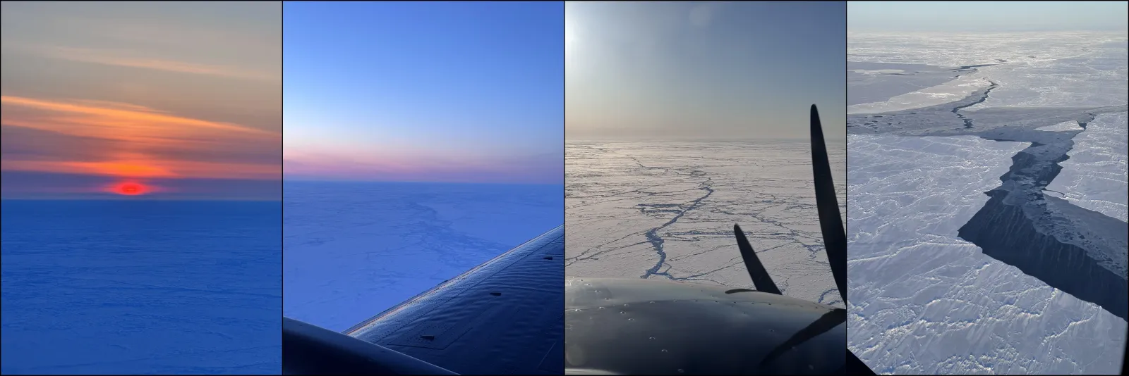
Engineers at NASA's Jet Propulsion Laboratory (JPL) in Southern California are testing a spacecraft sensor intended to measure how quickly Arctic sea ice is disappearing, using an April field campaign in Canada. For decision-makers, it is a behind-the-scenes reminder that better algorithms for ice thickness take real airborne validation before the next satellite generation.
This month, engineers at NASA's Jet Propulsion Laboratory (JPL) in Southern California are testing a spacecraft sensor designed to measure how quickly Arctic sea ice is disappearing. Even though the instrument will not launch for another year, scientists are already putting the measurement approach through a high-stakes dress rehearsal, flying instruments over the Arctic Ocean in April and timing those flights to match satellites passing overhead.
During that two-week campaign, the NASA team logged about 50 hours in the air, often watching sunrise from an altitude of 1,500 feet (457 meters) in a World War II-era plane. Flights were timed to the passage of satellites overhead so airborne and orbital data could be combined for the same features. The goal is to improve sea-ice thickness estimates by validating how multiple precise inputs come together: how high the sea ice rises above water, how deep the snow sits on top, and the microwave emissions from the surface.
That combination is not academic busywork. Measuring sea ice thickness is tricky because the ice and snow geometry directly affects what instruments “see.” In this campaign, the aircraft carried a variety of sensors used to measure thickness and snow properties, including a stand-in for the microwave radiometer now undergoing testing at JPL. The timing matters too. Sea ice is constantly shifting, breaking apart, and deforming as winds and ocean currents push it around. By capturing the same patch of ice from both the air and space, researchers can better connect what a plane measures in detail with what satellites observe from above.
If you only look at the Arctic as a photo from space, it is easy to miss the chaos underneath. The ice can be attached to land or adrift in the ocean, rough or smooth. Cracks can open into long stretches of exposed ocean, and collisions between floes can build massive ridges that extend for miles. Some sea ice lasts only one season, while thicker ice can survive for several years, even though multiyear sea ice is becoming less common in many parts of the Arctic. Those changes ripple outward to ecosystems and even the day-to-day reality of communities and wildlife, including arctic foxes and hares the scientists spotted during the trip.
And yes, it also affects people who care about risk, routes, and planning. The source notes that improving measurements of ice extent and thickness helps scientists understand how climate conditions are evolving across the Arctic. It also supports navigation, weather and ocean research, and future satellite observations. As Arctic shipping activity increases, the region becomes more strategically and economically significant, which means measurement quality is not just a science priority. It is a decision priority.
For the specific campaign design, NASA coordinated with other missions to strengthen the link between the aircraft observations and space-based instruments. For the Inuvik portion of the campaign, the team coordinated with the Surface Water and Ocean Topography (SWOT) mission, a satellite jointly developed by NASA and the French space agency CNES, with JPL leading the United States component. Although SWOT was designed to map the height of the globe's sea and fresh water, it can also measure the amount of sea ice above the waterline. In Cambridge Bay, the NASA team joined researchers from ESA (European Space Agency), Germany's Alfred Wegener Institute, and Canada's University of Calgary, coordinating flights over a field camp and under satellite tracks such as NASA's Ice, Cloud, and land Elevation Satellite-2 (ICESat-2) and ESA's CryoSat-2.
This is also where the “boardroom relevance” shows up: future missions depend on validated algorithms. ESA is developing, with cooperation from NASA, a new polar mission called Copernicus Polar Ice and Snow Topography Altimeter (CRISTAL). During the April airborne campaign, scientists flew instruments similar to what CRISTAL will carry, including the microwave radiometer undergoing testing at JPL. “Combining observations from space, air, and ground surface instruments is essential for developing and validating algorithms for current and future missions,” Sahra Kacimi of JPL, who served as the field campaign's science lead, said in the source. For executives overseeing tech programs, the subtext is straightforward: you do not get reliable spacecraft outputs without ground-truthing, and you do not get ground-truthing without logistics, timing, and cross-agency alignment.
Finally, the story includes the human angle that often gets lost in mission briefs. Kacimi has spent years studying sea ice using satellite data, but she emphasized in the source that for people living in the Arctic, the ice carries a deeper meaning than a global-climate variable. She spoke to community leaders and students at a STEM camp about how disappearing ice affects their communities. For decision-makers watching Earth observation and climate intelligence evolve, the stakes are both scientific and social: better measurements help the research community refine models, while practical users gain improved situational awareness across weather, oceans, navigation, and the planning needs that rise when the Arctic becomes more active.
This story's Key Insights and Take-aways are locked.
Create a free account to unlock Executive Actions for one credit.
Register to UnlockAlways free for Executives Club members. Join the Club
More in Science
Alaska's 1,580-foot tsunami had warning signs. Scientists just found them.
Rapid glacier retreat, heavy rainfall, and thousands of tiny tremors preceded Alaska's 1,580-foot tsunami, a warning for every coastal community in a warming world.

The rare mutation that lets high-risk brains dodge Alzheimer's
Scientists found a natural defense against protein buildup, opening a new path to preventive treatments.

3,000 steps a day may halve Alzheimer's decline, study finds
New research links a modest daily walk to less tau buildup and nearly half the cognitive and functional decline, even for those with early signs.