

Landsat 9 spotted alluvial fans growing on Severny Island, proving Arctic erosion is active
A new August 1, 2025 satellite image captures sediment forming cone-shaped fans across Russia’s Novaya Zemlya.
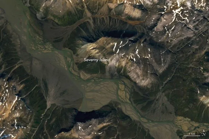
NASA Earth Observatory published a Landsat 9 image of Severny Island (Ostrov Severnyy) acquired August 1, 2025, showing alluvial fans forming along a braided river valley. For decision-makers, the scene adds another measurable piece to how warming alters glacier meltwater, sediment transport, and Arctic landscape change.
On August 1, 2025, Landsat 9’s OLI (Operational Land Imager) captured a Russian Arctic landscape where sediment is clearly being pushed, deposited, and reshaped: cone-shaped alluvial fans along Severny Island’s braided river valleys. In other words, this is not a “frozen in time” postcard. It is geomorphology with a pulse.
The key visible clue is the alluvial fans themselves. On the southern end of Severny Island, rivers rush down from ice-capped, rugged terrain into a broad valley. Once the water hits flatter ground, it slows and spreads sediment into fan-shaped deposits. Several fans appear in opposing orientations alongside the braided river in the Landsat 9 image highlighted by NASA Earth Observatory (NASA Earth Observatory/Lauren Dauphin).
Severny Island sits in the frigid high latitudes of the Northern Hemisphere and is part of the Novaya Zemlya archipelago. It is mountainous and uninhabited, and much of it is covered in glacial ice. Some glaciers terminate in the sea, while others end on land, feeding meltwater into glacial streams. That matters because the formation of alluvial fans depends on sediment-laden water. Where meltwater and streams can deliver eroded material, and where topography forces rivers to slow, divide into channels, and drop what they are carrying, fan building becomes likely.
This is also why the “where” of the fans is so telling. NASA notes that alluvial fans typically form at the base of steep mountain ranges, where narrow channels open onto flatter terrain. Rivers can slow, break into smaller channels, and deposit sediment. Over time, channels migrate back and forth, building up fan-shaped deposits rather than leaving a single static deposit. In the wider view, NASA shows ice-capped mountains interrupted by broad valleys lined with these alluvial fans. Seasonal snowmelt and glacial runoff likely keep Severny’s rivers supplied with enough material to keep doing the work.
Now zoom out from the picture to what it implies for Arctic change. Hydrologists cited by NASA note that higher river flows during warmer months, driven by snowmelt, can carry more sediment out of the mountains. Glaciers also produce large volumes of eroded material as they grind downslope, and some of that flushes out in meltwater. The source specifically flags land-terminating mountain glaciers as particularly prone to melting as the atmosphere warms, which increases the probability that streams will deliver sediment to valleys where fans can develop.
The island itself is described as relatively understudied due to remoteness. But satellite observations fill part of the gap by offering consistent, repeatable views. NASA references recent analyses incorporating digital elevation models that found land-terminating glaciers across the Novaya Zemlya archipelago thinned during the 2000s and 2010s, especially at lower elevations. The message for leaders is simple: even without boots on the ground, the combination of visible landforms from space and longer-running elevation analysis supports an emerging narrative of warming-driven change. Małecki (2022) examines contrasting glacier behavior across the European High Arctic using ArcticDEM data; Melkonian et al. (2016) reviews recent changes in glacier velocities and thinning at Novaya Zemlya.
If you are a board member, investor, policymaker, or operator in climate-risk-adjacent domains, this kind of satellite-driven “land change evidence” is more than pretty mapping. It is a second-order input into risk models and planning assumptions, because sediment transport and meltwater timing influence everything from downstream geomorphic stability to how quickly landscapes can reorganize after seasonal pulses. Today’s image is localized, but it plugs into a larger system: higher meltwater and warmer months mean more water movement and more sediment delivery, which helps explain why these fans exist now and not only in the distant past.
NASA Earth Observatory published the story with additional context and references (including a 2009 NASA Earth Observatory entry on Novaya Zemlya) and notes that the alluvial fan concept is supported by general science education references as well. The takeaway: even in uninhabited, remote parts of the Arctic, warming signals can show up in physical landform change that satellites can observe in near-real time, using tools like Landsat 9’s OLI. For peers tracking Arctic dynamics, that means the “data frontier” is not only about ice loss totals. It is also about what meltwater does to the world underneath it.
This story's Key Insights and Take-aways are locked.
Create a free account to unlock Executive Actions for one credit.
Register to UnlockAlways free for Executives Club members. Join the Club
More in Science
Alaska's 1,580-foot tsunami had warning signs. Scientists just found them.
Rapid glacier retreat, heavy rainfall, and thousands of tiny tremors preceded Alaska's 1,580-foot tsunami, a warning for every coastal community in a warming world.

The rare mutation that lets high-risk brains dodge Alzheimer's
Scientists found a natural defense against protein buildup, opening a new path to preventive treatments.

3,000 steps a day may halve Alzheimer's decline, study finds
New research links a modest daily walk to less tau buildup and nearly half the cognitive and functional decline, even for those with early signs.